The first snow survey of 2019 has been released by the provincial government’s River Forecast Centre and it indicates that generally, most areas of the province have a near normal snowpack for this time of year.
The data for the report is gathered from 69 manual snow courses and 80 automated snow weather stations around the province (collected by the Ministry of Environment Snow Survey Program, BC Hydro and partners).
READ: East Kootenay snow pack rises to 150 per cent of ormal in May 2018
READ: East Kootenay snow pack normal fo January 2018
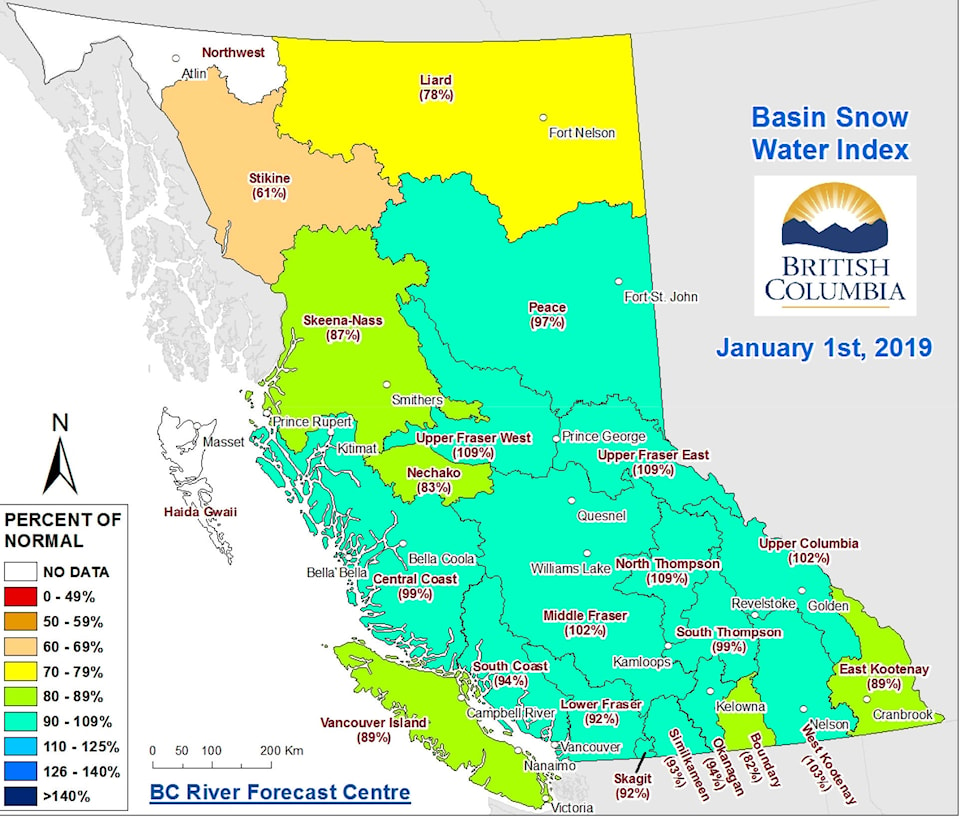
Snow basin indices for January 1st 2019 range from a low of 61 per cent of normal in the Stikine to a high of 109 per cent in the Upper Fraser West, Upper Fraser East and North Thompson.
In the East Kootenay, the snow pack is at 89 per cent of normal, while in the West Kootenay it is at 103 per cent.
The average of all snow measurements across the province at 96 per cent. Below normal snowpack (60-80 per cent of normal) is present in the Stikine, Nicola, and Liard.
The River Forecast Centre is using a new method for calculating snow basin indices in 2019, which will provide greater consistency in the calculations between basins, and reduces the bias created from extremely high or low percent of normal values at individual basins. The Centre is re-analyzing historic snow basin index values using the new method to allow for comparison going forward.
As for what can be expected weather-wise for the rest of the winter, the forecast is that an El Niño is likely.
Typically, El Niño is linked to warmer winters across British Columbia. During El Niño, snow packs tend to be lower than normal; however, there has been a large range of variability in snowpack in BC during El Niño winters in the past (for example 2007 was following an El Niño winter and had significant snowpack across the province). Warm sea surface temperature anomalies have also persisted in the Pacific Ocean off the BC/Alaska coast, with a general weakening in the anomaly since midNovember. Warm temperature anomalies in the Pacific often have a similar or enhancing effect when they occur in phase with El Niño, as was the case in 2014-15 and 2015-16. Seasonal weather forecasts from Environment and Climate Change Canada are indicating an increased likelihood of warmer than normal temperatures through the winter period.
By early January, nearly half of the annual BC snowpack has accumulated.