An area restriction around the Connell Ridge wildfire has been issued by the BC Wildfire Service, as the continues to grow to over 1,142 hectares, according to an update Friday morning.
The area restriction means no one can enter the defined area unless they are travelling to and from a home that is not under an evacuation order, have permission from a fire official, or are assisting in fire suppression efforts.
The area restriction will be in effect until Oct. 15.
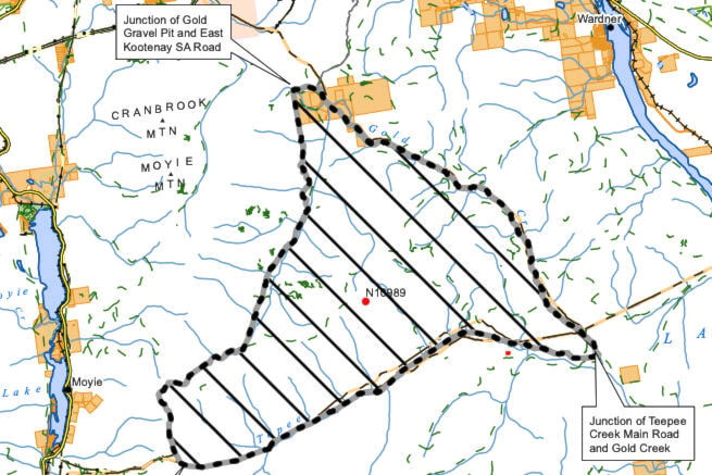
The boundary runs from the junction of Gold Gravel Pit road and East Kootenay SA, west and south along Baker West Road to Gold/Joseph Connector, continuing south on Gold Creek Watershed road and Gold Creek Main, southwest along the height of land to Teepee Creek Main, continuing northeast on Teepee Main to Gold Creek, north west to the point of commencement along Gold Creek.
Travel will also be restricted on the Gold Creek FSR and Teepee FSR within the boundary.
The Connell Ridge wildfire has grown by 200 hectares on the north and northeast flank, which is in steep and inoperable terrain according to the BC Wildfire Service. Cooler temperatures slowed down aggressive fire behaviour on Thursday and into Friday, however, that is expected to change over the weekend as temperatures in crease.
There are 66 firefighters, five helicopters and 13 pieces of heavy equipment assigned to fire response.
Machine guard is being built from the southeast corner to the southwest corner to establish a containment line, while crews are also working to determine a suitable location for east flank and northwest flank containment lines.
A Structure Protection Specialist is also developing strategies for structure protection in the area.
An evacuation alert for six properties south of Mount Baker remains in effect, according the RDEK.
Elsewhere in the region, the Weasel Creek wilfire, which started in the United States west of Roosville, has crossed into Canada and is approximately 250 hectares, according to the BC Wildfire Service.
A small one-hectare blaze is also burning in Gilnockie Provincial Park east of Yahk.