The BC Wildfire Service reported Monday evening that the Plumbob Mountain fire, burning 18 kilometres west of Baynes Lake on the west side of Koocanusa, had exhibited moderated behaviour on Monday after blowing up very quickly the previous day.
Strong, gusty winds caused the fire to rapidly grow to rank 4 and spread quickly in a northeast direction on Sunday. Firefighters along with nine airtankers, three helicopters and four pieces of heavy equipment responded immediately. Later in the afternoon, heavy smoke hampered visibility and the ability of aircraft to continue to fight the fire.
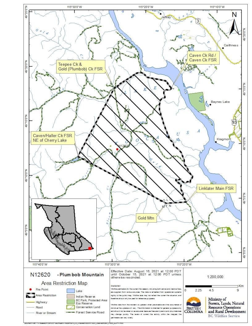
On Monday morning, observed fire behaviour had moderated and better visibility allowed for more accurate mapping, resulting in a reduction of the estimated fire size to 286 hectares.
Resources continue to be mobilized in a full response to the fire with the objective of full containment. As of Monday afternoon, skimmers and heavy equipment, along with ground crews and helicopters, are making good progress on the fire.
Today’s cool, wet weather will assist fire crews.
Nevertheless, the fire remains out of control at the present time, and a number of area restrictions have been put in place on the west side of Koocanusa, a very popular recreation area.
The restriction applies to Crown land within the geographic boundaries described below and outlined in the correlated map:
• Commencing on the West side of Lake Koocanusa at Caven Creek FSR.
• Caven Creek Road continuing west-northwest along Teepee Creek Main FSR to intersection with Teepee Ck.
• Gold Creek (Plumbob Creek) FSR continuing in a straight line southwest to a point on Caven.
• Haller Creek FSR at northeast corner of Cherry Lake, continuing in a straight line southeast to Gold Mountain then directly east in a straight line to Linklater Main FSR following Linklater Main north to Caven.
• Gilnockie Crk FSR proceeding NE along Caven.
• Gilnockie Crk FSR back to point of commencement.
Travel along the Teepee Creek FSR and the Linklater is permitted but access into the restricted area from those FSR’s not permitted.
Under this Order and section 11(2) of the Wildfire Act, a person must not remain in or enter the restricted area, unless the person:
1 first receives written authorization of an official designated for the purposes of the Wildfire Act, or
2 enters the area only in the course of:
• travelling to or from his or her residence, that is not under an evacuation order;
• travelling to or from private or leased property for the purpose of accessing a secondary or recreational property, that is not under an evacuation order;
• using a highway as defined in the Transportation Act;
• travelling as a person acting in an official capacity as defined in s.56 of the Wildfire Act; or
• travelling for the purpose of supporting wildfire suppression or enforcement patrol activities.
A detailed map of the affected area is available: http://ow.ly/dHjY50FSdqU
Road closures and area restrictions are subject to change depending on fire activity. For the most current information please visit the bans and restrictions section of the BC Wildfire website for the Southeast Fire Centre, or visit: http://ow.ly/usva30rPN6i.
The Southeast Fire Centre extends from the U.S. border in the south to Mica Dam in the north, and from the Okanagan Highlands and Monashee Mountains in the west, to the B.C.-Alberta border in the east.
To report a wildfire, unattended campfire or open burning violation, call 1 800 663-5555 toll-free or *5555 on a cellphone. For the latest information on current wildfire activity, burning restrictions, road closures and air-quality advisories, visit: http://www.bcwildfire.ca or download the BC Wildfire App free for Apple and Android devices.
READ: Evacuation alert issued for west side of Lake Koocanusa due to wildfire
carolyn.grant@kimberleybulletin.com
Like us on Facebook and follow us on Twitter