The East Kootenay has been labouring under the frigid temperatures that come with an extended high pressure system. The good news is, the high pressure systems that have dominated the weather for the past four weeks are being pushed out by advancing Pacific air masses. Temperatures are rising, and the backcountry beckons for recreationalists.
But be warned: the weather that entices us out into the mountains is also perfect avalanche weather.
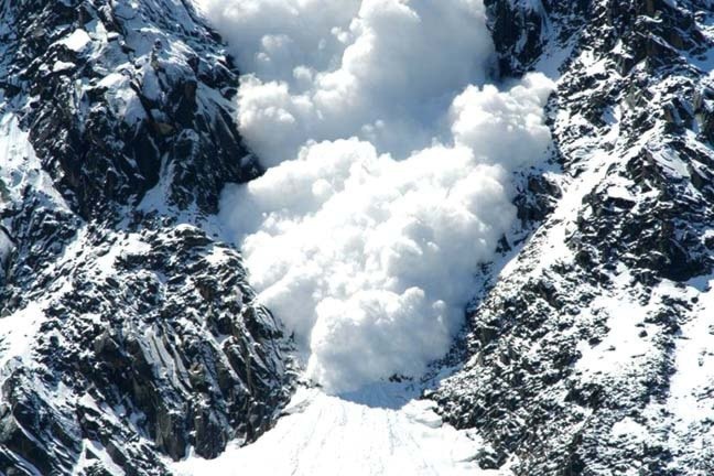
The Canadian Avalanche Centre is warning that the avalanche danger rating for the Purcells, the Lizard Range east of Cranbrook and the South Rockies has jumped to considerable to high this week.
"We have a definite change in the weather pattern here," said Stephanie Lemieux, a forecaster with the Avalanche Centre, based out of Revelstoke. "One system after another is going to be coming through the province and hitting the region with a significant amount of precipitation, with some strong winds, and also the temperatures are going to be warming up, but not enough so we'll see rain.
"So lots of snow, lots of load from the wind and all that good stuff is sitting on some weak surfaces that were created with the past cold temperatures we've had."
With the expected significant snowfall over the next few days, the Avalanche Centre said widespread storm slabs are developing. The slab of new snow on top of an underlying weaker layer has created unstable conditions. And with all that load on the snowpack's surface, Lemieux said, the snowpack is going to try to find its balance. "And for sure we expect quite a bit of natural avalanche activity."
The avalanche bulletins released Monday said "thick and touchy windslabs will also develop in the lee of southwest and west winds in the alpine and at treeline. Loose avalanches are also a concern on all aspects, at all elevations. Be sure that your plans allow for a safe exit from the backcountry as increasing snow and strong winds quickly increase avalanche hazard late in the day."
Backcountry skiers, snowboarders and sledders should be wary of the dangerous conditions on mountains across much of southern B.C.
"It's a little bit more than the usual cautions at this time," Lemieux said. "We're going to have some high avalanche danger coming. Slopes will just avalanche on their own, and go quite far into the run-out zones. Your normal precaution is not enough. People will pretty much have to stay out of areas that they may usually go.
"We're not saying 'don't go out,' at all, but people are going to have to select some really safe terrain outside of avalanche terrain. And if people don't have training or avalanche gear, maybe it's a good idea to not go at all."
Snowpack in the Purcells
The Avalanche Centre advised that in the Purcells, "just underneath the settled storm snow and raggedy old wind slabs lies a significant weakness composed of large surface hoar (widespread in most sheltered and shaded areas at all elevations), a sun crust on south facing slopes, faceted grains (in colder areas or areas with a thinner snowpack), or a combination of the above.
"This variable weak layer is expected to become a problem early next week when precipitation once again graces the province. The rest of the snowpack is generally well consolidated.
"In isolated areas where the snowpack is thinner or in steep rocky features a facet/crust weakness near the ground remains a concern. In most places the depth of this layer combined with the strength of the overlying slab makes triggering an avalanche unlikely. However, if you were unlucky enough to find a weak spot the consequences could be deadly serious."
Snowpack in Lizard Range
The new snow is sitting on a variety of weak layers such as surface facets, on a new surface hoar layer in sheltered areas, or on windslabs in the alpine. The bond of the new snow with these surfaces is expected to be poor. Don't let the powder excitement get in the way of safe decision making. It is good time to make conservative terrain choices and to reduce your exposure to avalanche terrain.
"25-50 cm below these layers exist another surface hoar or suncrust layer that was buried late in January. Recently this layer has not been very reactive and seems to be very localised, however, yesterdays skier triggered avalanche proved that it is still present and triggerable at treeline."