The East Kootenay snow pack rose in February, although not as much snow accumulated as might in previous years.
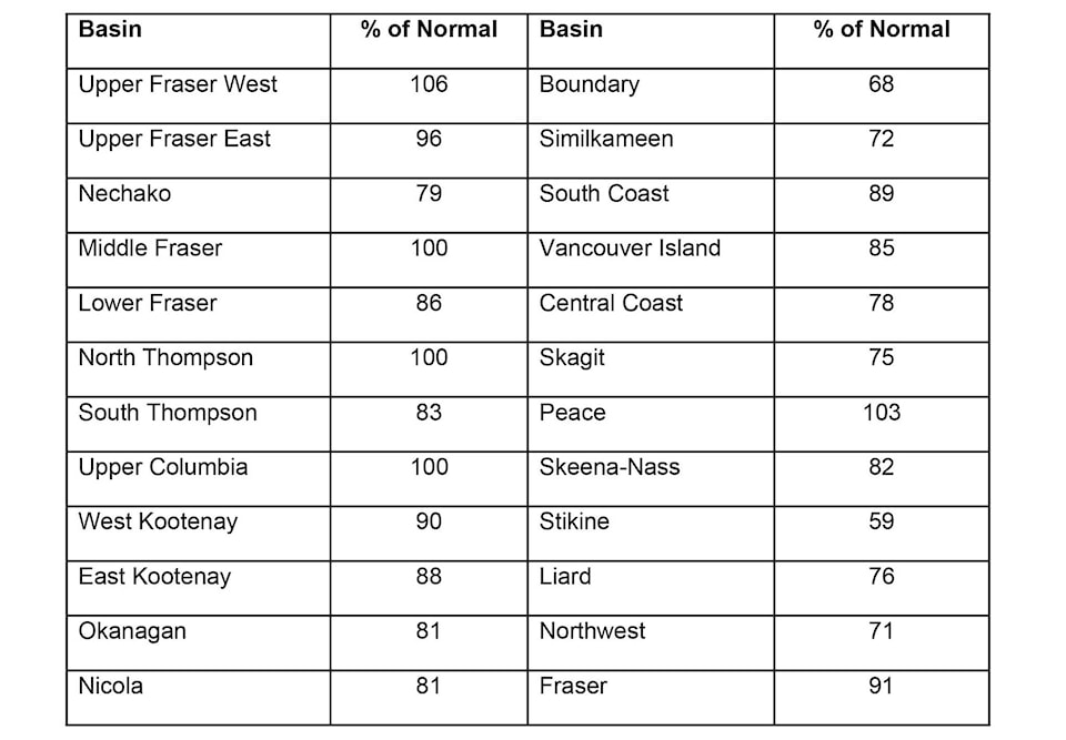
The snow pack in the East Kootenay is at 88 per cent of normal according to the BC River Forecast Centre, up five per cent from last month.
READ MORE: East Kootenay Snow Pack drops in January
February was very cold through the entire province as a stable arctic airmass remained in place for most of the month, according to the latest report from the River Forecast Centre. Many cities recorded the coldest or second coldest average temperature for February. Temperature anomalies along the coast were -4 to -5˚C below normal; anomalies in the southern interior were -6 to -9˚C below normal, and weather stations in the north were up to -12.5˚C below normal. Precipitation was variable in February throughout Environment and Climate Change Canada’s provincial climate stations. Some stations were dry (e.g. Terrace) and some had greater than normal precipitation (e.g. Williams Lake). However, higher elevation automated snow weather stations recorded very low precipitation relative to normal conditions.
The province ranges from well below normal snowpack to normal snowpack for March 1st, with the average of all snow measurements across the province calculated to be 89% of normal. Well below normal snowpack (<60% of normal) is present in the Stikine, while below normal snowpack (60- 80% of normal) exists in the Similkameen, Skagit, Central Coast and Nechako. The rest of the province has slightly below normal to normal snowpack (80-110% of normal). There are no regions of the province with exceptionally high snowpack. The March 1st snow basin index for the entire Fraser River is 91% of normal. So far this season, snow accumulation has been dominated by persistent weather patterns. Most of this years’ snowpack built up rapidly over a five to six-week period from earlyDecember to early-January. Weather through February shifted into the dominance of Arctic air across the province, with extremely cold temperatures and limited snow accumulation. This pattern has continued into the beginning of March. Snowpack throughout the province remained relatively level through February. Most basins dropped by 5 to 15% relative to normal compared to February 1 due to the dry and cold conditions.
According to the U.S. National Weather Service there is a high likelihood of El Niño continuing through spring 2019.
Typically, El Niño is linked to warmer winters across British Columbia, with a trend towards lower than normal snowpack. Warmer temperatures were present throughout the province in December and January. However, a strong arctic airmass significantly influenced British Columbia in February and offset these typical El Niño impacts. February temperatures through the province were much lower than normal, reaching record lows in several regions. The impact of El Niño on winter snowpack in BC is highly variable and does not always mean lower snowpack - for example, 2006-07 had significant snowpack across the province. Seasonal weather forecasts from Environment and Climate Change Canada show an increased likelihood of below normal temperatures for most of the province over March to May.
By early March, nearly 80 per cent of the annual BC snow pack has usually accumulated. with snow packs low to normal across the province, the Forecast Centre is not anticipating any flood risks at this time, however that could change as there are two more months of possible snow accumulation.
carolyn.grant@kimberleybulletin.com
Like us on Facebook and follow us on Twitter