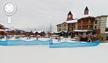
Prospective visitors to Kimberley Alpine Resort will soon be able to take a virtual tour of every run on the mountain thanks to Google Maps.
The Google crew was in Kimberley last year to capture the view of the slopes and it will soon go live on Google Maps.
“It’s a really cool program,” said Matt Mosteller, VP for Resorts of the Canadian Rockies, owners of KAR. “They did the shooting last year with a high tech camera on the back of a snow mobile. You get a 360 degree view of every run. You go to the map of the run and you can see what it’s like to ski. You get a really great view of all the slopes.”
The Resort base is there now, and there are just a few more things to finish up and all the slopes will go live.
“We’ve signed off on all the things at our end,” Mosteller said. “We are really thrilled with this. The first ski hill in Canada to do this was Whistler. We said you guys have got to come back up. RCR urged them to come back to showcase the ski resorts in this area.
“It gives a really unique view of the Resort, the terrain, the trees. It’s a look you can’t really get from a brochure. It simulates what it’s like to ski Kimberley.”