Tom Lymbery of the Gray Creek Store has always been a promoter of the Gray Creek Pass, and its chief historian.
This August is the 30th anniversary of the Pass, but Lymbery says its roots go much further back, to the time of explorer David Thompson.
“The Gray Creek Pass has always been the shortest link between West and East Kootenay,” Lymbery said. “It was rated by Russell Musio of Backroad Mapbooks as the Most Important Backroad in BC.
“It might have been possible for surveyor David Thompson to travel up the St Mary’s River in 1808 and over the pass to Kootenay Lake. That was what Thompson’s Indigenous guide “Ugly Head” recommended (so named for his curly hair), but Thompson refused this option.
In his ‘Thirty Years for Gray Creek Pass’, Lymbery recounts that in 1949 Cominco was ready to reopen the Bluebell Mine at Riondel, but there was yet no electric power on the East Shore. Cominco also desperately needed more electric power at Kimberley to be able to add its fertilizer operations.
“This would require taking a power span across Kootenay Lake. Crossing the lake with an unsupported high voltage power line had never been done before. Many years earlier the same had been suggested in order to electrify the Spiral Tunnels on the main CPR track. But now two-mile-long electric cables were available, and the head office in Montreal advised taking these across the ice, only to learn that this lake is the largest ice-free lake in Canada. (Please read “The Span” for details on this challenging project.)
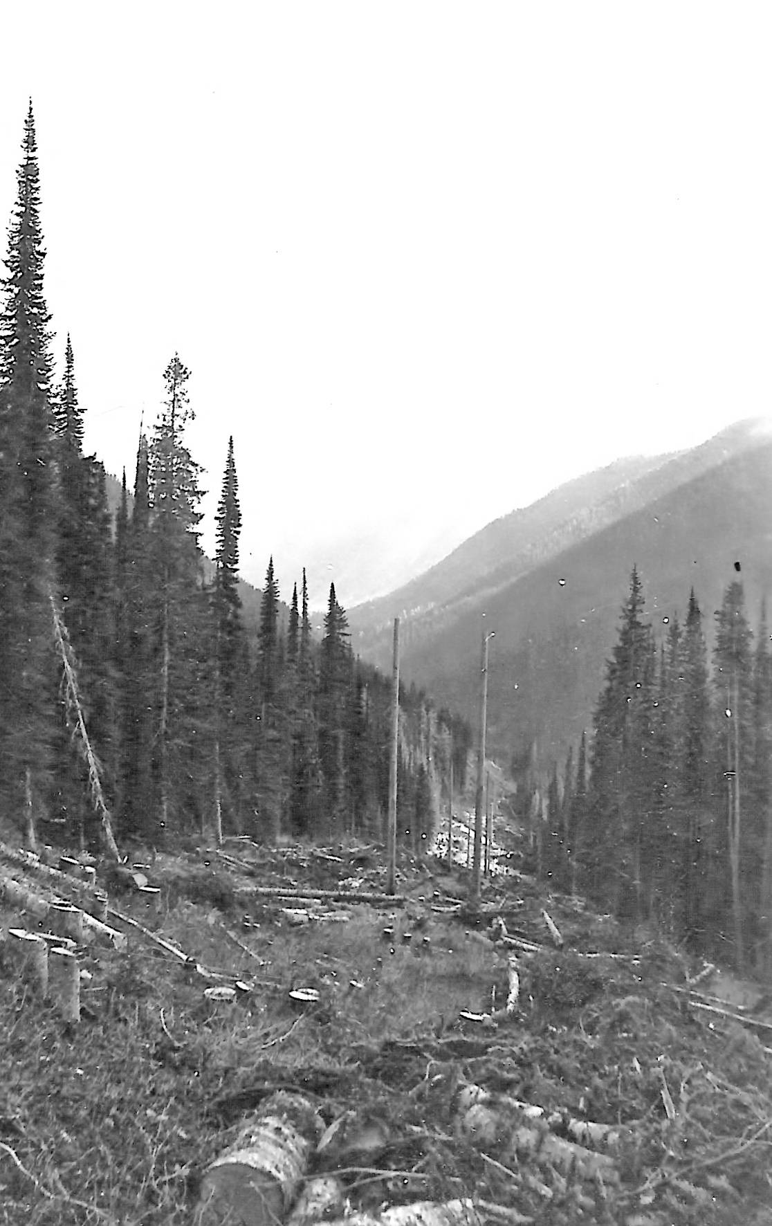
“Richie Deane, Cominco’s head electric engineer was charged with finding the most feasible route for the new power line across to Kimberley. I remember Richie showing me maps with the contours coloured for easier comparison of the various passes. After deciding on the Gray Creek valley, Bill Dunbar began surveying the route. Warren Keer was brought in from Kimberley with his pack train to haul instruments and supplies for the survey crew. He followed George Oliver’s trapping trail to his cabin, not too far from the summit. By 1952 the project was completed with a rough road to service the powerline, and Kimberley had enough power to plan smelting iron.
“The new powerline road renewed interest in a shortcut route to Kimberley which would be passable for regular vehicles. Many Cominco employees who had relocated from Kimberley to Riondel were keen to have a shorter route back to their families and friends in East Kootenay. There were immediate requests to upgrade the basic powerline road which at the time needed a sturdy 4-wheel-drive vehicle. A promotional society was formed with the slogan “Rose or Gray – There Has To Be a Way”. Even Wayne McDougall of Woodland Supplies in Nanaimo (distributors of PM Canadien chainsaws) joined, as his two sons were attending hockey school in Kimberley. Horst Wirsig told me that he could build the road if he had funding, as his Gray Creek Forest Products was already logging up the south fork of Gray Creek.
“In late June 1963 Sharon and I were invited on a promotional trek over the pass,” Lymbery said. “We were all driven in a number of 4 x 4s across the summit and down to 13 Mile on Redding Creek. There we met fellow trekkers from Kimberley who put on a spaghetti dinner for all. Any vehicle from the Kimberley side could get as far as Mile 13 even at that early date. The missing link was the remaining 13 or so mile section to Gray Creek. John Learmonth. Divisional Greyhound Superintendent in Nelson posted a sign on the summit showing mileages to towns from Vancouver to Calgary. He said that if a highway was built over the pass it would be the shortest route across BC by 50 miles.
“Completion of the Kokanee Springs Golf Course in the late 1960s helped to push for a more passable road. Eventually Howard Dirks became our Social Credit MLA for Nelson – Creston, and he promised a new road if we would ensure his re-election. We did, and he followed up on his promise.
“Soon surveyors were at work on the new Gray Creek Forest Service Road (Gray Creek Pass road for short) connecting the East Shore of Kootenay Lake with Kimberley. Nelson Forest Division road superintendent George Commandeur planned and supervised the construction of the new road. To avoid the very steep ascent to the Gray Creek Summit, they chose to follow the South Fork of Gray Creek to find easier grades, averaging a 9% grade. Work progressed over two years with some logging of the right-of-way. As the road was designed as a Forestry Main Haul route, it has a lot of two-lane width built in for passing, and sweeping corners to allow even the longest logging trucks or tractor trailers to negotiate easily. If the road been built in the 1950s, I am sure John Learmonth would have routed a seasonal Greyhound bus to Kimberley, as the new road is much better than “The Hump”, the old road from Rossland to Christina Lake. It was so named by Greyhound drivers for its two summits and corners which required buses to back up. Our Gray Creek Store supplied 8 inch Ardox (twisted) nails for the wooden bridges, but they soon used up our stock. Don Lindsay of Lindsay Hardware in Bonners Ferry found he could order these from a log building supplier, so I had a trip to Bonners to get these.
“Forestry signposted a small lake “Johnny Oliver Lake” below the summit, which Johnny protested and got them to change to Oliver Lake. A trail crew built small bridges and split boulders so that you can walk around this gem. They also set up picnic tables and an outhouse to make it a Recreation Site. This is a popular drive from Gray Creek to eat a picnic lunch there and then return. Many summits consist of some swamp that drains either way, but this is a real summit with the road dropping away both east and west. I once came across some golfers on the summit who were shooting golf balls, and alternating shots from east to west.
“On official opening day in August 1990, Forestry chartered five buses to take people up to the summit, as there is limited parking space up there. BC Minister of Forests Claude Richmond officiated at the official opening, and Harold Prussin , president of our Kootenay Lake Chamber of Commerce presented him with a T-shirt with Garfield the cat on one side looking happy, and on the other side looking exhausted “after crossing the Gray Creek pass.” A thousand of these T-shirts have gone to many countries in the past 30 years.
“ German tourists in rental motor homes once drove over the pass each season, after a map in a German “West Kanada” travel book originally showed the pass road as a solid line while Highway 3 Creston – Cranbrook route had a dotted line. But they had no trouble with the new road for several years - until Victoria started cutting back on maintenance. When construction of the new road was originally announced, BC Highways promised up to $25,000 annually for maintenance, but this never came through. If they had a gravel crusher it would have made the surface much smoother and more gradable. Tina Zimmerman, the Nelson engineer for the western portion, keeps the ten miles to the summit in excellent shape. However Len Palajac of Cranbrook is unable to do the same with his much longer portion, as the surface is all pit run gravel with too much stone.
“Ross Banner of Kimberley and Gray Creek pushed for the Pass to become part of the Trans Canada Trail and was successful. We see many cyclists and a few walkers from many countries coming through. Some go completely across Canada on the Trail. Lennard Pretorius of Kamloops organized BC Epic 1000, a 1066 km competitive cycle from Merritt to Fernie along the Trans-Canada Trail and over the Gray Creek Pass, running from west to east. Early riders pass through Gray Creek on July 1st each year.”