The East Kootenay is switching from emergency to recovery as creek and river levels begin to decline. However in Wasa, the flood is still on its way.
According to a statement from the Regional District of East Kootenay's information officer Loree Duczek, things are improving across the region.
In Kimberley, Mark Creek and Kimberley Creek levels are dropping, stabilizing the flood situation.
The highway through Wasa is now open to single lane alternating traffic, but the threat at Wasa Lake is by no means over.
The Kootenay River peaked Saturday evening and levels have begun to decline. However it takes seven to 10 days for Wasa Lake to see the effects of high water in the river. It's expected that water in Wasa will rise quickly.
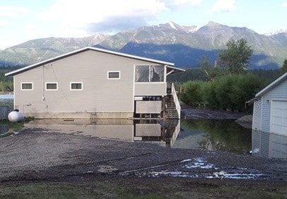
A sandbagging station has been set up at Wasa Community Hall. Water Stewardship BC has also been in the Wasa area completing assessments near the Lake and Cameron Pond. The water level in the slough end of Cameron Pond dropped about 0.4 metres yesterday. There is an area along the old roadway between Cameron Pond and the slough that is showing some signs of erosion, so it is being monitored.
"We are encouraging residents and property owners in Wasa who are near the water to ensure valuables are moved out of basements, and take steps to prevent belongings from being affected by floodwater," said Duczek.
In Hosmer, evacuation orders were rescinded Sunday with residents allowed to return home. The Forest Service Unit Crew stacked 3,000 sandbags ready to put into use at the Hosmer Fire Hall. Clean up kits were expected to arrive from the Red Cross Monday.
A meeting was held in Hosmer with 75 people in attendance and provided the community with information and an opportunity to ask questions.
The alert for Elko Dam, at risk of giving away due to the volume of water over the weekend, was cancelled on Sunday. BC Hydro personnel remain on site and will continue 24 hr surveillance while water levels remain high.
Fernie remains in a state of local emergency. There was localized flooding in the Annex, and pumping took place Saturday afternoon with success. The storm water system is handling the water at this time. The ponding in the streets in the Annex has dried up. All dikes are holding. All City parks remain closed and City crews are beginning the task of identifying areas of erosion and debris piles on the trails.
In Sparwood, the focus is beginning to turn to recovery, as city staff begin to assess trails and parks for damage. Efforts are underway to replace a water line that was damaged during the flooding.
There is still a state of emergency in Elkford, where work continues on debris management in Boivin Creek. Access for residents north of Elkford is a priority, as is access to the district's sewage lagoons.
In the Columbia Valley, Dutch Creek south of Fairmont is down, although an evacuation alert remains in place. Heavy equipment continues to move rock and add rip rap reinforcement along the banks of Dutch Creek and the work is about 90 per cent complete. Clean up efforts are well underway by the campground owner and the campground has no notable water or diverted creek flow.
Fairmont Creek and Cold Spring Creek are within their channels and running clearer. There is continued sedimentation and debris removal management is ongoing.
Meanwhile, the B.C. Ministry of Forests, Lands and Natural Resource Operations was cataloguing the condition of forestry roads on Monday.
"For the next few days it would be great if people avoided backcountry roads. We don't want to get people trapped out there," said Dave Rebagliati at the Ministry's Cranbrook office.
Forestry staff were scheduled to fly over the backcountry roads in the central region Monday if weather allowed, while Canfor does the same in other areas.
"Then we will have to prioritize things and look for funding and see what we can fix and what we can't fix. There's just not many dollars out there," said Rebagliati, adding that roads to popular backcountry recreation areas will be a higher priority.
"Anywhere that there is active logging, the licensees will start repairs as soon as it's safe to do so," he said.
Closed forest service roads include Wildhorse, Mause Creek, Summer Lake, Bull River, Whiteswan, St. Mary's Lake and Findlay.
For a detailed list of what roads are closed and where, visit www.for.gov.bc.ca/drm/services/road-works.htm.